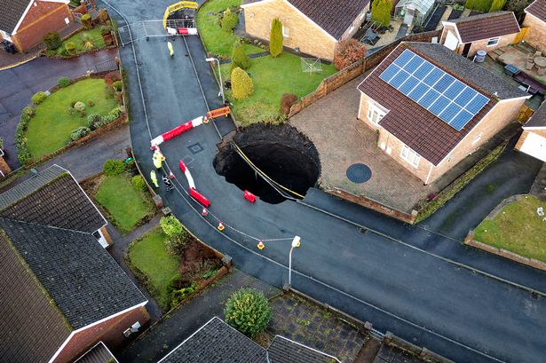
The sudden appearance of a substantial sinkhole in the Nant Morlais area of Pant, Merthyr Tydfil, South Wales, triggered immediate evacuations and a flurry of geological investigations. This dramatic event disrupted the lives of residents as approximately 30 homes were evacuated, forcing families to seek temporary shelter and raising concerns about the stability of the surrounding land. The unsettling sight of the earth opening up served as a stark reminder of the powerful subterranean forces that shape the landscape and the potential for unexpected geological hazards to impact communities. Authorities swiftly cordoned off the area, urging residents to stay clear of the sinkhole due to the inherent dangers of unstable ground and the possibility of further collapse. The initial focus was on ensuring the safety of the residents and preventing any injuries from potential further subsidence.
The immediate aftermath of the sinkhole’s appearance saw a coordinated response from various agencies. Geological experts were dispatched to assess the situation and determine the underlying cause of the ground collapse. Initial theories focused on the area’s rich mining history, suggesting that the sinkhole might be related to the complex network of abandoned mine shafts and tunnels that honeycomb the region. These underground voids, left behind from decades of coal extraction, can become unstable over time, leading to subsidence and the formation of sinkholes. Geologists employed a range of techniques, including ground-penetrating radar and borehole drilling, to map the extent of the subsurface cavities and evaluate the risk of further ground collapse. Simultaneously, emergency services provided support to the displaced residents, arranging temporary accommodation and ensuring their immediate needs were met.
As investigations continued, the focus shifted from immediate emergency response to a more comprehensive understanding of the sinkhole’s formation and the long-term implications for the affected community. Detailed geological surveys revealed the complexities of the subsurface geology, highlighting the interplay between natural geological processes and the legacy of mining activity. While the presence of abandoned mine workings undoubtedly played a significant role in the sinkhole’s development, other factors, such as the underlying rock strata and the movement of groundwater, also contributed to the instability. The analysis of historical mining records, combined with advanced geophysical surveys, allowed experts to build a three-dimensional model of the subsurface, providing valuable insights into the potential for future subsidence events.
The sinkhole incident in Nant Morlais underscored the importance of proactive ground risk assessments, especially in areas with a history of mining. The potential for similar incidents to occur in other parts of the region prompted calls for a more systematic approach to identifying and mitigating these risks. Recommendations included regular monitoring of ground movement in high-risk areas, using advanced technologies such as satellite-based interferometric synthetic aperture radar (InSAR) to detect subtle changes in surface elevation that could indicate potential subsidence. Furthermore, experts advocated for the development of more robust land-use planning regulations that take into account the potential for ground instability, ensuring that new developments are located in geologically stable areas.
The displacement of residents also highlighted the need for comprehensive emergency preparedness plans. While the immediate response to the sinkhole was generally effective, the incident revealed areas for improvement in terms of communication, coordination, and support for affected residents. Recommendations included the development of clear protocols for evacuations, the establishment of dedicated support centers for displaced residents, and the implementation of robust communication strategies to keep residents informed about the situation. The experience in Nant Morlais served as a valuable learning opportunity, prompting a review of existing emergency plans and the development of new strategies to ensure a more effective and coordinated response to future incidents.
The long-term recovery from the sinkhole incident in Nant Morlais will likely involve a combination of engineering solutions and community resilience. Stabilizing the ground around the sinkhole and mitigating the risk of further subsidence will require significant engineering interventions, potentially including grouting the underground voids or constructing retaining walls. The restoration of the affected area and the eventual return of residents to their homes will depend on the successful implementation of these engineering solutions. Furthermore, the incident highlighted the importance of community support networks and the resilience of the affected residents in coping with the disruption and uncertainty. The Nant Morlais sinkhole event served as a powerful reminder of the dynamic nature of the earth beneath our feet and the need for proactive measures to manage the risks associated with geological hazards.


