



From Scorching Records to Sudden Chills: The UK Weather’s Dramatic Reversal
The United Kingdom has just emerged from an extraordinary meteorological chapter, one that rewrote the record books and delivered a taste of Mediterranean heat to its shores. The final days of May 2024 were nothing short of historic, as a potent heatwave engulfed the nation. This wasn’t merely a warm spell; it was a record-shattering event. The national weather service, the Met Office, confirmed that an astonishing 23 separate weather stations surpassed the long-standing UK maximum temperature record for May, which had been 32.8°C and stood since 1922. The pinnacle of this heat was reached at Kew Gardens in Greater London, where the mercury soared to a remarkable 35.1°C on Tuesday, 26 May. For many, it was a surreal period of sweltering sunshine that felt profoundly un-British for the time of year, transforming parks into beaches and prompting widespread discussions about the intensity of modern weather patterns.
However, as the calendar turned to June, the atmospheric script flipped dramatically. The Met Office has now confirmed that this blistering chapter is conclusively closing. The high-pressure system that delivered the stagnant, intense heat is breaking down, making way for a more familiar and dynamic Atlantic influence. In a official update, forecasters stated the heatwave “will gradually reduce in intensity in the coming days,” heralding a significant shift. The forecast points toward a transition to “more unsettled and cooler weather by the weekend for many,” a change that will be widely felt across the country. This shift marks the end of the stable, sunny skies and the beginning of a more changeable and seasonally typical British weather pattern.
The process of cooling down will be ushered in by a weakening cold front moving southeast across the UK through Friday and becoming established by Saturday. Met Office Chief Forecaster Chris Bulmer explained that this front will bring “fresher conditions,” a euphemism that will be welcomed by some and mourned by others. As the heat dissipates, the weather will grow increasingly unsettled. The forecast indicates the rising likelihood of showers and even thunderstorms for some areas as the contrasting air masses interact. By the weekend, temperatures are expected to fall much closer to the average for early June, accompanied by rainfall for many regions. This signals a full return to the kind of mixed conditions that often characterize a British summer, a stark contrast to the consistent heat of the previous week.
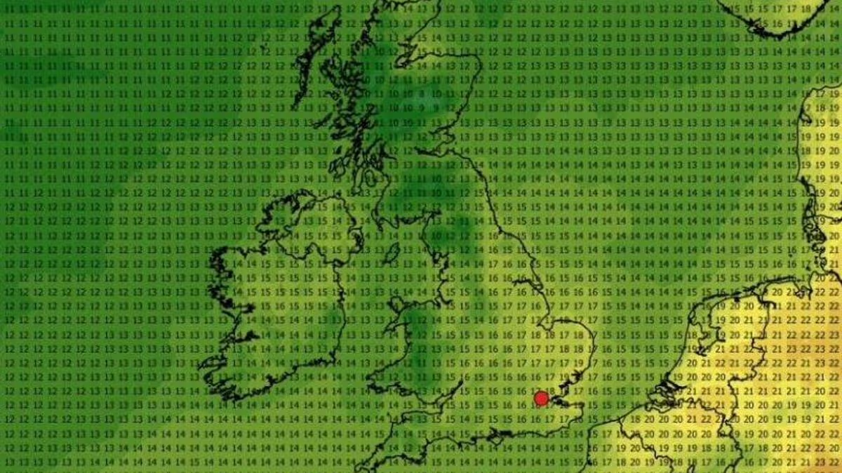
The most startling aspect of the new forecast, however, is just how far temperatures are predicted to plunge. Detailed weather maps from sources like WXCharts suggest a dramatic cooldown is on the horizon. While maximum daytime temperatures across much of the UK next week are expected to hover in the more manageable mid-teens Celsius, the early morning hours could be surprisingly chilly. The maps indicate that by 7 a.m. on Sunday, 7 June, temperatures in parts of Scotland—particularly around the junction of the Highlands, Aberdeenshire, and Perth and Kinross—could plummet to a mere 5°C. At that same hour, much of England, Wales, and Northern Ireland would also be experiencing a crisp start, with readings generally between 7°C and 11°C. This represents a breathtaking swing from the highs of 35°C just days prior.
Looking ahead into the following week, the weather is expected to remain broadly unsettled. The Met Office’s long-range forecast for the period into mid-June suggests that “Atlantic weather systems are expected to move in from the west,” bringing periods of showers or longer spells of rain. The west and northwest of the UK are likely to see the most frequent rainfall, while the south and east may hold onto slightly drier, albeit still cloudy, intervals. Temperatures during this period are forecast to be near-normal overall, with any lingering warmth most probable in eastern areas. It will also be breezy at times, especially in western coastal regions. However, there is a glimmer of hope for those craving stability, as the forecast hints that “drier weather may start to become more dominant as we head into the second week of June.”
This rapid journey from record-breaking heat to potential morning frost encapsulates the volatile and unpredictable nature of the UK’s climate. The nation has cycled from an extreme, unprecedented heatwave directly into a period of cool, wet, and blustery conditions more archetypal of its geographical position. It serves as a potent reminder of how quickly weather patterns can transition, bringing relief to some and disappointment to others. For now, residents are trading in sunscreen for umbrellas and light fabrics for layered jackets, adapting once again to the ever-changing British skies as the weather resets to a more familiar, if less sensational, summer tempo.